
The Rend Trail and the Ace Adventure Resort “Waterfall Trail”
6/13/22 continued from West Virginia Waterfalls: Wolf Creek Falls and Friends. After spending the night at ACE, Shooter and I decide to hike some nearby trails. I thought I could create a loop hike using the Rend Trail and the Arbuckle Creek Trail (aka “Waterfall Trail” at ACE) to see two or three waterfalls and a mining site. An old, faded trailhead sign marks the beginning of the Rend Trail. The Rend Trail, which is officially on National Park Service land, seems to be kind of forgotten about. Located near the town of Minden, WV, away from many of the main attractions of the park, you wouldn’t know there was a trail here unless you came looking for it. About a mile into the hike, I pass two men heading the opposite direction who don’t have any hiking gear– no packs, poles, not even a water bottle between the two of them– and thought that was odd. I’m not one to spook easily, and nothing about them seemed threatening, so I wasn’t worried about them. I’d wager lots of local kids probably use this trail to go into the woods to smoke pot.
The Rend Trail is a “rail trail” — formed by converting an old railroad bed into a walking and biking path. Rail trails are usually flat and wide, and easy to walk, which was exactly what I wanted on this scorching hot day. I intended to hike down the Rend Trail to the Arbuckle Connector, take the connector over to the Arbuckle Trail aka the “Waterfall Trail” at ACE, and then connect the two trailheads via a short road walk.

Unfortunately, this turned out to be impossible. At ~1.3 miles into the hike I abruptly come to a locked gate with a “trail closed” sign. Not gonna lie, it would have been nice if there had been signage at the trailhead stating that the trial was closed. I could have saved myself some time and gotten in a more productive hike. You’d think those two dudes I passed could have warned me about the closure as well!
I said “unfortunately” above but this really turned out to be a blessing in disguise. As I return to the car I find there to be a pack of stray dogs wandering around at the trailhead. If Shooter and I had road walked back from the upper trailhead, we’d have had to cross the lot and possibly encounter the dogs head on, which could have spelled disaster. We avoid them and head up to ACE to attempt the trail from the other direction.

This trail is referred to as the “Arbuckle Creek Trail” on some maps and in some publications. There are at least two waterfalls along this trail: Upper Falls of Arbuckle Creek and Double Falls. These waterfalls were mentioned in a couple of guidebooks, and I knew where the trail was because it’s on the ACE Adventure Resort property maps you get when you check in to camp there. Now that ACE owns the trailhead, it seems that the Upper Falls has been renamed “Finn’s Falls” and this is the official name that I’ve seen in most West Virginia publications.
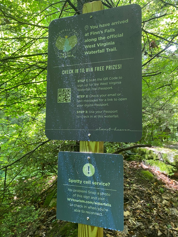
There’s a sign at Finn’s Falls with information about the West Virginia Waterfall Trail, a “passport” that currently contains 29 waterfalls. You can check in at each waterfall you visit to earn prizes. I looked it up once I had cell signal and I had already been to five of them! I checked in and earned a sticker.
I continue down the trail from Finn’s Falls to find Double Falls. It’s worth it to mention that I’m really struggling on this hike. I really wasn’t feeling the best all day, and I’m not sure if its the heat, or if I’m dehydrated, or if I’m sleep deprived but the whole hike is a struggle. I was ready to be done before I even started. I almost didn’t go past Finn’s Falls, but I was already here and figured I may as well suck it up and at least try to find Double Falls.

I’m able to get a view of one drop of what I believe is Double Falls from the trail. There is a second drop (hence “double” I assume?) that I’m unable to get a clear view of. I’m not sure if this is the waterfall or not, but I’m ready to be done with this hike so I take a photo and called it a day.
When I finally make it back to the car, I’m hot, sweaty, and feeling rather defeated. First was the dead-end Rend Trail, then there was not being sure about whether or not I saw Double Falls, and finally was the fact that I just did not feel well. I didn’t enjoy these hikes very much. I get in my car, drive up to my mountain-top campsite at ACE, and take the most fabulous COLD shower of my life. Feeling much refreshed, I change into non-hiking clothes and head down to the Lost Padde, ACE’s on-site bar and grill, for some wings and a cold beverage before settling in for the night. I highly recommend ACE Adventure Resort as a basecamp for exploring this part of NRG if you’re like me and enjoy amenities such as flush toilets, showers, and an on-site bar. Sites are only $15/night. I’ve stayed here several times now, and have enjoyed it each time.
Fern Gulch Trail to Upper Fern Creek Falls
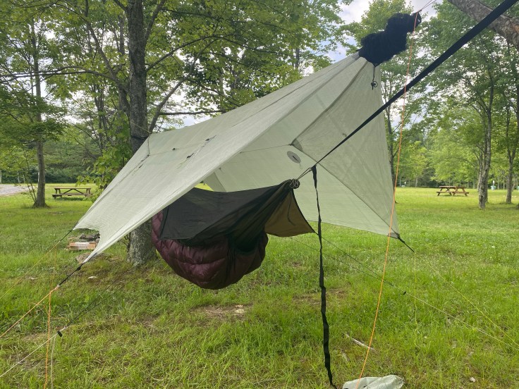
6/14/22 It stormed like hell last night. For hours, rain came in sheets, thunder boomed all around, and lightening cracked, lighting up the sky as bright as daylight. I slept in my hammock anyway, knowing that I’ve weathered many storms in my trusty old Blackbird. By morning, the rain has stopped and I plan my hike for the day while eating a bacon, egg, and cheese sandwich I made on my camp stove. The forecast calls for another scorcher despite the all night thunderstorms, so I know I want to hike near water. There are a series of waterfalls along Fern Creek that have captivated me since I’ve been in West Virginia. Having previously tried to get to Upper Fern Creek Falls and failed, I decide to give it another go, via a different route. I’d read about an alternative route to this creek in a guide book, and had confirmed the existence of a climber’s trail along the base of the cliffs, called “Fern Gulch,” with a climber I met at the bar at Cantrell when I was camped there earlier in the week.
I park along Fayette Station Road to begin the hike and immediately noticed several “no trespassing” signs. Checking my Gaia app, which has a public land overlay, I notice that the trail I’ll be taking probably does briefly cross private land before re-entering the National Park. I had been assured by the climber and by a raft guide that you could hike here, and the trail showed plenty of signs of use– most likely by climbers using it to access the climbing areas. A guidebook I have also mentions this trail, though it discusses the highlight being a stone “face” carved into a rock near a small waterfall. I decide to go for it, being careful to stay on the trail and hopefully off of someone’s private land. If you have morality issues with possibly trespassing, this is probably not the trail for you.
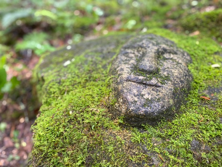
I quickly find The Face, so I know I’m on the correct trail. Just down the trail from the odd stone carving was “The Face Falls” and a short spur trail leading down to the base. I decide to save it for the return and keep moving. I eventually pass a tree with some yellow paint on it. Upon checking Gaia again, I find that this is the National Park boundary; I can relax a little knowing that I’m 100% on park service land now. This trail however is clearly not maintained by the park service. There’s significant blowdown that we climb under, through, and around, and the trail is heavily eroded in places. We eventually make it to the cliffs section and follow the base of the cliffs for a while. I don’t see another soul on the way in, and finally at about 1.3 miles Shooter and I make it to our destination. Or, we made it to where our destination was supposed to be.

I can hear the waterfall rushing through the narrow slot, but even from where I’m standing in this photo, I can’t see any water moving. In high flow, the water shoots out of the cavern into a dramatic free-fall. Today was no such day.
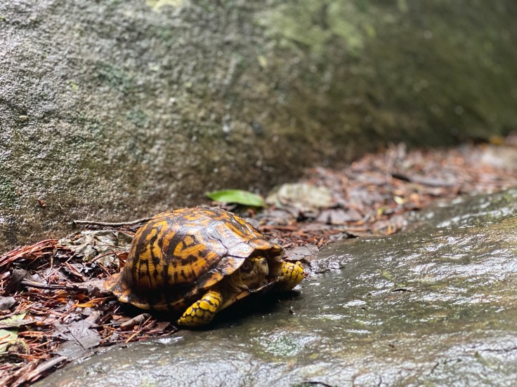
The rock formations were neat, and I did see a beautiful box turtle at the base of the “falls” so I’m not counting this one as a total loss. There are at least two, possibly three more significant drops on Fern Creek below this waterfall, but I didn’t bother to bushwhack down to any of them due to the lack of flow at this one.
On the way back, I’m listening to a podcast and trudging up and down the small hills at the base of the cliffs when my phone pings a text message notification into my airpods. Did I just see you on Fern Gulch trail? The message read. I had heard climbers above me on the trail, but didn’t actually see them as I passed. The message was from the climber I had met at Cantrell, the one who confirmed the existence of this trail to me. Yeah! Is it weird to come back and say hi? I respond. Please do! comes the return text, so Shooter and I retrace our steps back to where I had heard the climbers a few minutes before. Sure enough, he’s there with a climbing friend. They are having a snack and contemplating going swimming somewhere to cool off. Apparently, I’m not the only one who thinks this heat is oppressive. We make a plan to meet up later at Summersville Lake for a swim, and I finish my hike while they climb one more route.

On the way back to the car the heat is once again really starting to get to me. I’m eager to get back to The Face Falls, visions of standing underneath its shower-like free-fall dancing in my head. It doesn’t look like much, but it felt divine and I was glad to see it once I got there, and glad I’d saved the scramble down to it for the return trip.
After 2.6 long miles and 3 hours (what??? I can only guess that the blow down and my stop to chat with Trey and his friend slowed me down) I finally make it back to my car. I was going to make a sandwich, but I after finding my car now parked in direct sunlight, I decided to drive down to Fayette Station and picnic there, in the shade. After devouring a ham sandwich and guzzling an ice-cold seltzer from my cooler, I shoot a text to Devin, the raft guide from Cantrell, inviting him to the lake with us.
We swim until sunset, enjoying the cool, crystal clear water of Summersville Lake– still the prettiest lake I think I’ve ever seen, then have dinner at a phenomenal Mexican restaurant before heading back to Cantrell to camp one final night. Tomorrow I have to go back to Charleston to start another long stretch of days at work. I had a phenomenal week overall, and have fallen in love with this little slice of the Mountain State. I could do without the heat, but I’ll be back soon!
