
Amanda and I awake at Stuart Campground and begin packing. I’ve been here for two nights, and Amanda one. She’s using my second hammock this week, so I take down mine and then help her with the other one. We make breakfast and discuss our day. There are some waterfalls on a creek called Big Run of the Blackwater River that I want to try to locate. Nearby, off the same forest service road, is Olson Firetower. This is our plan for today, before heading over to Blackwater Falls State Park to set up camp for the night.
Waterfalls of Big Run
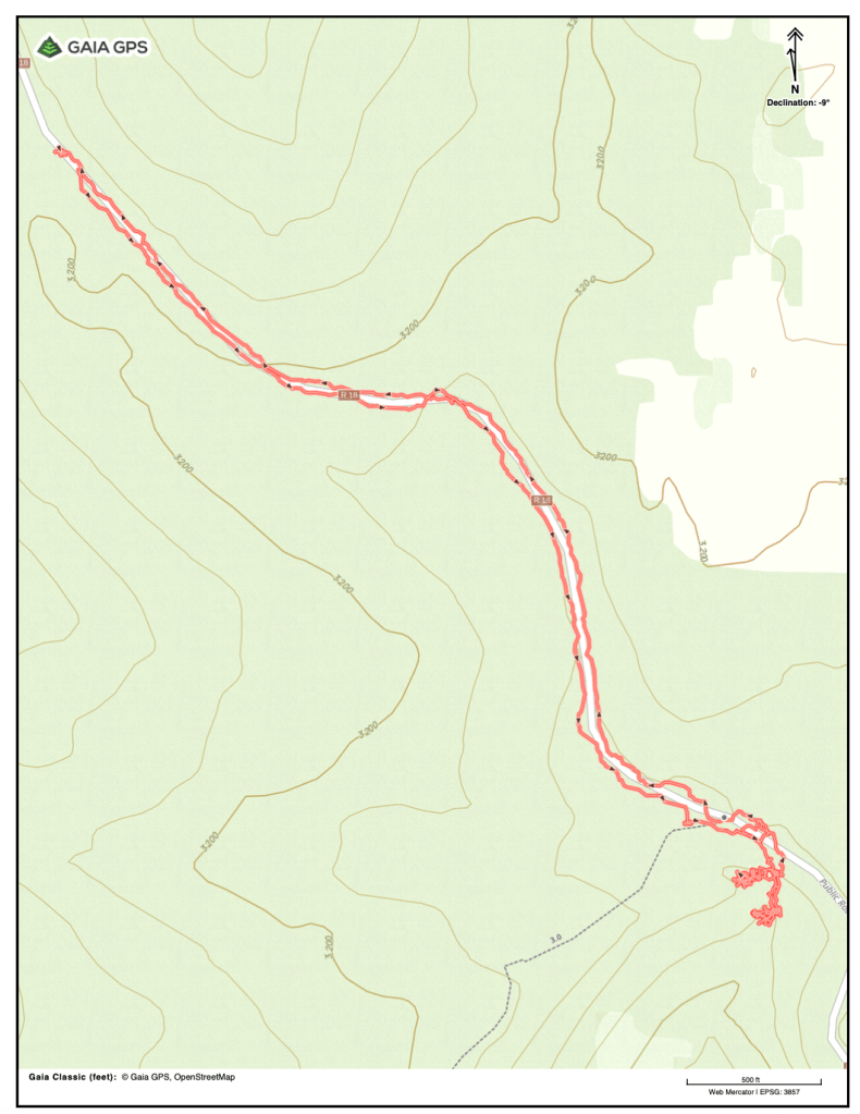
After breakfast we drive toward our destination. Once we reach FS 717- Backbone Ridge, we leave Amanda’s car at a pull-out and she hops in with me. She drives a hybrid sedan, and I’m unsure what the road conditions will be like further up. I’ve heard that FS 18, which intersects FS 717 and is the road we will be taking to access Big Run Falls, is often in rough shape. The USFS Roads and Trails overlay in Gaia tells me it is suitable for passenger cars, but we decide not to take the chance.
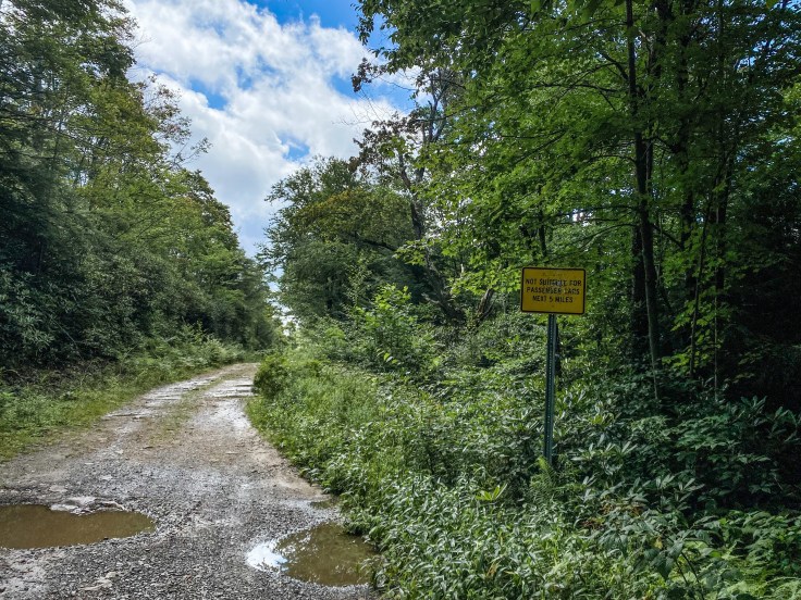
The first mile or so IS suitable for passenger cars. However, we eventually reach a wide spot in the road where a sign reading “NOT SUITABLE FOR PASSENGER CARS NEXT 5 MILES” warns us of the condition of the road beyond.
The road is rutted and full of potholes, and there’s an area where a concrete bridge over a culvert has washed out. We could have driven it but it would have been a bumpy ride, and the walk is nice. We are on the lookout for a campsite on the right-hand side of the road which signals we are close to the trail. We reach it after about ¾ of a mile, a large wooded site with several fire pits right next to the creek. This would be an awesome spot to camp, and I make a note of such in Gaia for future reference.
We spend some time looking around for the trail, which isn’t marked. We previously considered taking a trail marked “Canyon Rim Trail” between here and Olson Firetower, and we locate what we believe to be this trail. Based on the way it is blazed, I mention that I think this is probably part of the long-distance Allegheny Trail.
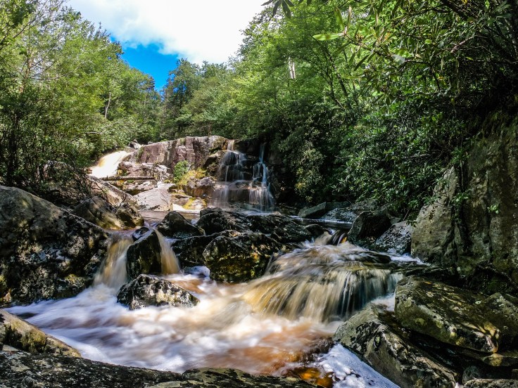
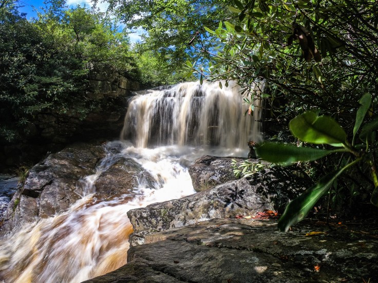
I walk down the road a little further and find a boulder with a faded arrow painted on it pointing into the woods. This must be the trail down to the falls, and I shout for Amanda to join me. There is not an official or maintained trail, so the path we follow is steep, rooty, muddy, and washed out. We carefully make our way down toward the sound of falling water until we reach an intersection. We choose the more downhill route, and after some clambering we arrive at the creek below the lower drop of Big Run. It isn’t immediately evident that this is the lowest drop of this three-tiered waterfall, but I say to Amanda, “this doesn’t really look like the pictures I’ve seen.” It’s impressive nonetheless, being swollen from recent rain showers.
While I’m taking photos, Amanda climbs up onto a nearby boulder and yells down to me that she can see another waterfall further up. “That is probably the one in the photos,” I reply. “I wonder if that upper trail fork will take us there.” We decide to give it a try and backtrack to the intersection. Sure enough, it takes us right to the base of the upper drop. This is the waterfall I’ve seen in photographs. We both carefully make our way to a large boulder near the base of the creek-wide drop and snap a few photos, taking a few moments to relish in the tranquility and beauty of this spot coupled with the intense and powerful rushing water.
By the time we are finished, both of our shoes are soaked from wading in the creek and our clothes are damp from the spray of the waterfall. These are the two most heavily weighed factors when we decide not to hike the Canyon Rim/Allegheny Trail up to the firetower and back. We’d both enjoy a longer hike today, but I know from past experience that hiking in damp clothes is a recipe for the worst chafing of my life, and we both now have wet feet. We decide to walk the road back to the car and drive around to the firetower.
Hike Details:
- Hike length (from passenger car parking): 1.84 miles
- Ascent: 131ft
- Time: 1h 39m
- Passenger car parking: 39.11496, -79.57792
- 4×4 parking: 39.10800, -79.56907
- Lower drop viewpoint: 39.10699, -79.56865
- Upper drop viewpoint: 39.10735, -79.56885
Tap image above to open the Gaia GPS track for this hike.
Olson Firetower
Our suspicions about the Canyon Rim Trail being part of the long-distance Allegheny Trail are confirmed as we drive to Olson Firetower. We spot a backpacker coming off the trail and there, next to the road, is a sign for the Allegheny Trail. When we pull into the small clearing where Olson Tower sits, I cannot contain my awe. I blurt out, “she’s TALL!” This has to be the tallest firetower I have ever seen, and I’ve seen a lot. I make a mental note to look up the actual height of the tower when I get cell signal again, and decide to make a sandwich before we climb to the top. This is in part because I’ve worked up an appetite and in part because a young couple arrived just before us and are currently making their way up the narrow tower steps to the small cab high above.
After my snack, it’s clear the couple isn’t coming down so we decide to head up the tower. The steps are exceptionally steep, and I climb slowly. Up, up, up it feels like I might never reach the top and will just keep ascending toward the sky forever. This tower has more steps than I think I have ever seen on a firetower. According to the USFS website, there are 133 steps, but I was too busy breathing to count them.
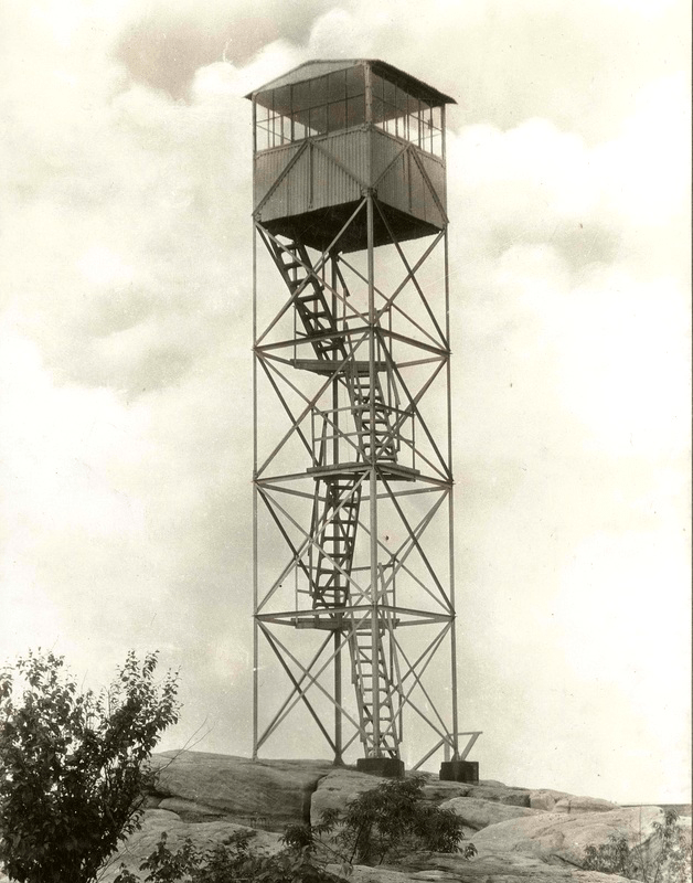
(Photo above shows the original Backbone Mountain Firetower circa 1935, courtesy of the national archives.)
The tower I’m currently climbing was built in 1963 to replace the Backbone Mountain Firetower, which was built in 1922. According to a Raleigh Register report from February, 1962, the Backbone Mountain tower was 60ft high and had to be replaced because the trees had grown so tall they obstructed the view. This same news report states that the new tower would be 100ft tall, but I was unable to locate the exact height of the tower as it currently stands.

The view from the top is nice, and even though web sources say the cab should be locked, it’s open today. Well, not exactly open. The trap-door padlock plate was attached to the wooden floor of the cab, which has apparently become so rotted that the plate tore off, lock still attached. The cab is heavily vandalized, low-quality graffiti and tags covering the walls and ceiling and several windows busted. We spend a few moments speaking with a photographer who climbs the tower after us and he mentions he plans to report the broken padlock plate and current state of the tower to the appropriate Forest Service officials.

We climb down the tower and drive back to where we left Amanda’s car. Our next stop is Blackwater Falls State Park, where we will camp tonight and visit some of the region’s most spectacular waterfalls.
