
For several years I’ve tried to get out to Colorado for a few weeks in the summertime. I’ve succeeded every year since 2017, with the exception of last year when I was deeply entrenched in one of the best summers of my life. Some years I fly, but my favorite way to visit Colorado is to road trip. Sure, it’s a long drive, but this way I have my own vehicle, all my camping gear, and can bring whatever I want. It also provides an opportunity to see some of those “flyover states” and explore some lesser-known areas. This year, I drove to Colorado for two weeks leading up to my attempt to summit Mount Kilimanjaro. I wanted to use this time to acclimate to altitude and get in loads of hiking. I talked a friend into joining me and off we went!
Day 1: North Carolina to Arkansas
Levon (trail name: Hard Hat) and I left North Carolina on Thursday, August 10 with a plan to arrive in Durango, Colorado on Saturday, August 12. This gave us about two and a half days to complete a twenty-six hour drive. We left in the afternoon on the 10th and planned to drive for about 6-7 hours before finding somewhere to dispersed camp for the night — our goal was to do this trip as low-budget as possible. While one of us drove, the other searched for camping options. We found a state park that, according to the website, had first-come first-serve sites and a self-service fee station. Perfect! We set our GPS for this location and arrived around 11pm to find the gate locked a few miles from the park. There was no explanation for why the gate was locked (do they just lock the campers in there overnight? Surely not right?) but we had no choice but to find something else. Back to the interstate we went, and I pulled up the Campendium app to do some searching.
Field note: Campendium is one of my most-used apps for finding campsites and campgrounds while traveling to new locations. I use it along side apps like Boondocking and websites like freecampsites.net to find free or low-cost camping options all over the country. Check out this post for more travel apps I use and love.
After locating a potential dispersed camping option at Dagmar WMA in Arkansas, we set our GPS for this location and hoped for the best. We wouldn’t have any amenities but hopefully it would be somewhere to sleep. Sure enough, after being routed down a dirt road for a few miles we came across some roadside dispersed camping areas. We pulled into one of the first ones we found, set up our shelters, and went straight to sleep.

Day 2: Arkansas to New Mexico with a stop at Magazine Mountain
The high-pitched and incessant buzz of mosquitos awoke me from a sweaty slumber in the early Arkansas morning. I could hear Levon stirring in his tent already. I opened my eyes and saw the army of swarming insects buzzing outside the bug net of my hammock, the only thing keeping me from becoming a veritable human buffet. I swatted at the netting a few times in an attempt to run them off long enough for me to unzip the hammock and sprint to the car for bug spray. It was little use. There were hundreds of them.
We both packed up quickly and hit the road, swatting mosquitos and sweating our asses off. Once in the car I noticed a rash running up my right forearm and I wondered what I managed to get into that irritated my skin. No telling, but at least it doesn’t itch so I forget about it. Today’s agenda included driving as far as we could possibly get, with a pit stop at the Arkansas state high point: Mount Magazine.
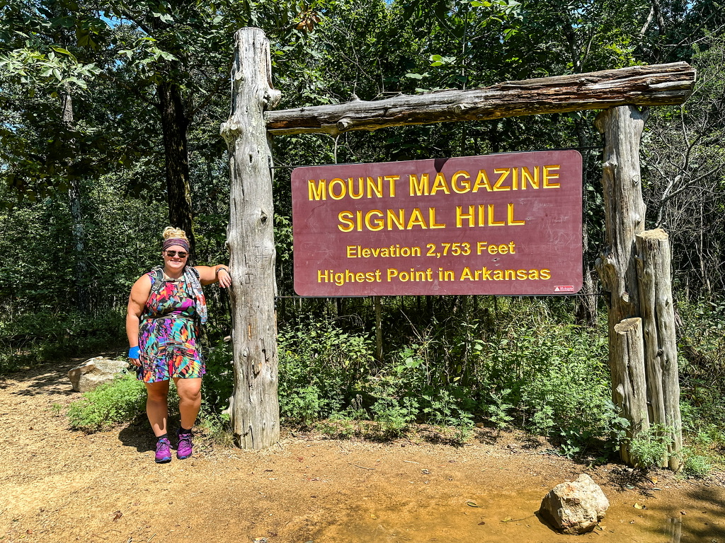

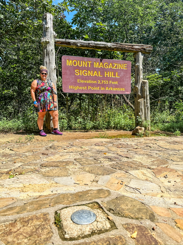
Mount Magazine is located within Mount Magazine State Park and is the highest point in the state of Arkansas, standing at 2,753ft above sea level. A very short hike leads to the summit from a variety of trailheads, but we chose to do a slightly longer loop beginning and ending at Cameron Bluff Campground.
| HIKE DETAILS | |
|---|---|
| Trailhead coordinates: | 35.17057, -93.64473 |
| Hike length: | 1.44mi (loop) |
| Ascent: | 161ft |
| Total Hike Time: | 49min |
| Surface: | Well maintained trail |
| Tink’s difficulty rating: | Easy |
After bagging the highest point in Arkansas, we stopped at an overlook for a picnic and then at the visitors center to grab a sticker and some free park maps. I got to chatting with the man working the cash register and found out about a fire tower in the same park. Unfortunately, the hike to it was way too long to do on this trip, but it sounds like a great reason to return here some day. Moving on, we left the park and set our sights west.

I had found a dispersed camping area in New Mexico that we were hoping to make before stopping for the night, but around 1am it became clear that both of us were too exhausted to keep driving. I located a free roadside park where we could have stopped to sleep in the car, but at 1am the outside temperature was in the mid-80s; it was much too hot for car sleeping. We decided to get a cheap motel for the night and I found one nearby in a small town on Route 66 called Tucumcari, New Mexico. I checked us in and we lugged our bags up two flights of stairs to a top-floor room. A tiny bat clung to the wall above the door, but at first glance the room looked and smelled clean. I used the restroom and then proceeded to do my cursory bed-bug check– a habit I got into while hiking the Appalachian Trail and staying in some pretty sketchy places.
When I pulled back the bed sheets I gaped in disgust; there weren’t any bed bugs but the sheets had blood all over them. I can overlook a lot of things but this isn’t one of them. I place a call downstairs and the nice young man who checked me in was horrified when I asked for a clean set of sheets and told him the reason why. He informed me that he didn’t have access to sheets so he would move us to a new room, but he wanted to come up and see the blood stains for himself. He was totally disgusted, as were we, and we moved to the next room over. This room also appeared and smelled clean, and the sheets passed both the bed bug and blood inspection. I showered and went to sleep.
Day 3: Tucumcari, NM to Durango, CO
I slept well despite the mattress being hard as a rock. Once again we awoke early. I crawled out of the uncomfortable bed and opened my duffel to get dressed for the day, only to find a cockroach crawling around in my luggage. This hotel is just full of unpleasant surprises. I proceed to unpack my entire duffel bag to find the roach, which crawled down into my clothes as soon as I noticed it, and finally locate it. Roach eradicated, I get dressed and we find a cute diner to eat breakfast at. This town is on the famous Route 66 and everywhere makes sure you know it. The diner is cute and the breakfast burrito I ordered is monstrous and delicious. We decide we will head north of Albuquerque and stop to see a few sites in the Jemez National Recreation Area of Santa Fe National Forest before driving on into Colorado. Our route of choice is New Mexico State Route 4, which will take us past several points of interest.

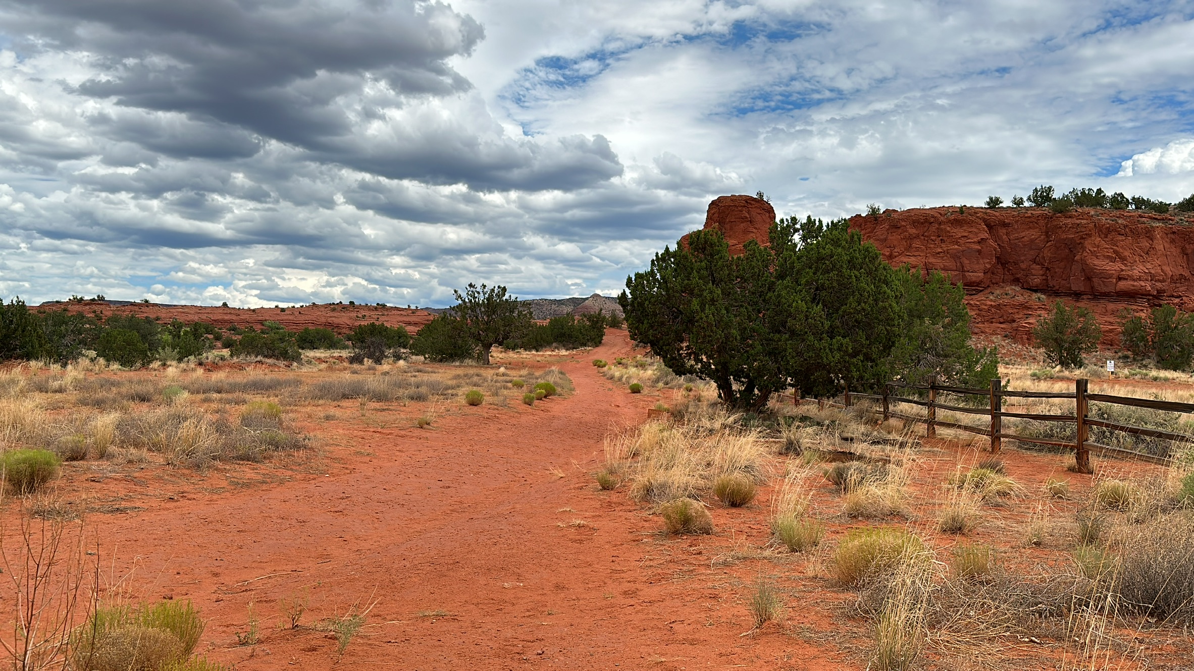
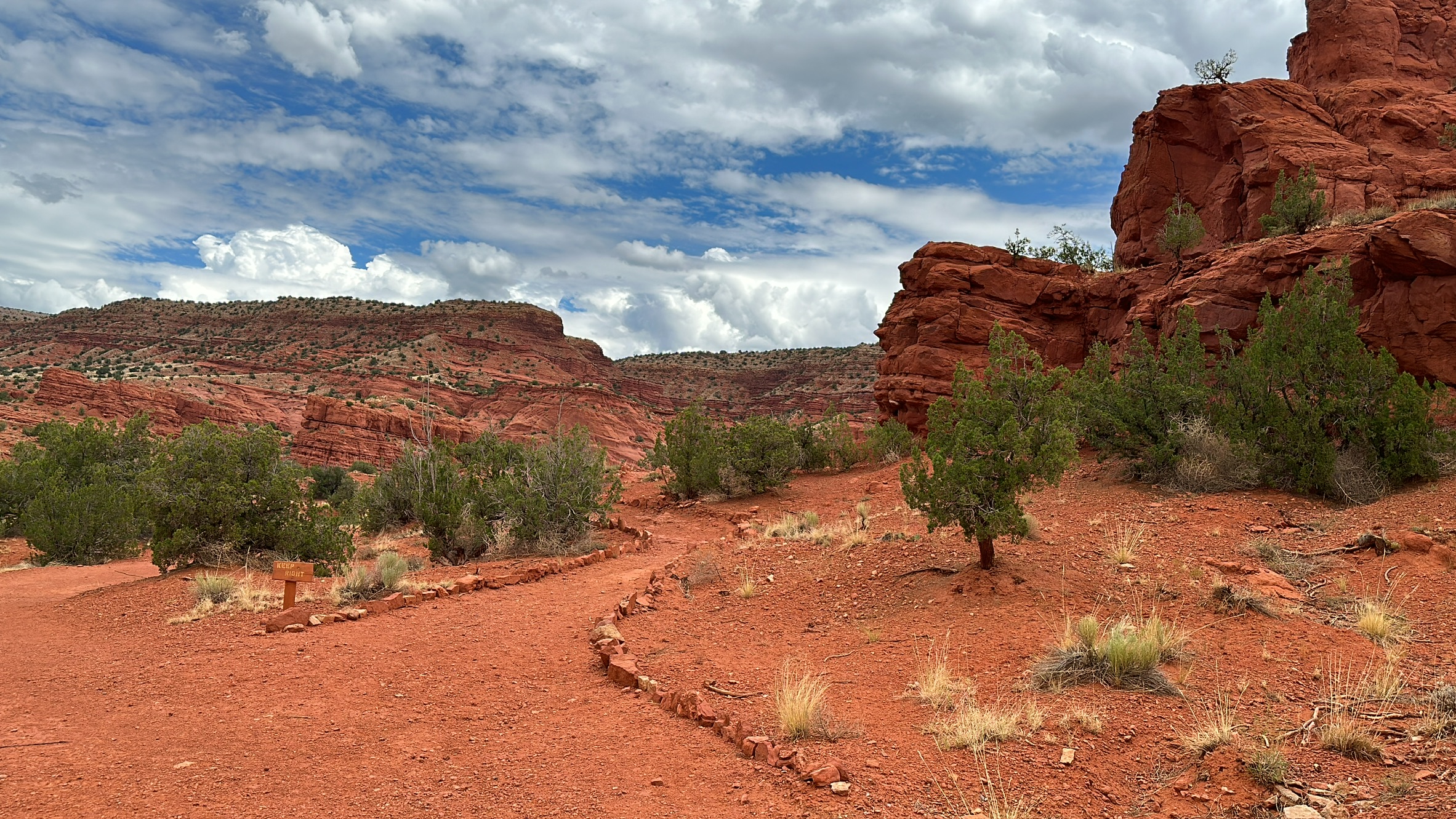
Red Rock Trail and Walatowa Slot Canyon
Our first stop is Red Rock Trail and Walatowa Slot Canyon. I found this hike on the AllTrails app and it looked gorgeous. We arrived to find out that the hiking area is maintained by the Pueblo of Jemez, a federally recognized tribe and independent sovereign nation. We happily paid $7 each for a hiking permit after looking around the interesting visitor center for a bit. I’m not often one to choose hikes that I have to pay to do, but being able to support the Jemez nation while enjoying a beautiful and sacred location was so worth it.


Field note: I primarily use GaiaGPS for backcountry navigation, mapping, and route finding. However, I do find value in using AllTrails to locate interesting hikes in areas I'm unfamiliar with. I advise using the AllTrails app but maintaining an inquiring mind and always searching for additional information on the hikes you choose, as AllTrails is notorious for having false or outdated information.
| HIKE DETAILS | Red Rock Trail & Walatowa Slot Canyons |
|---|---|
| Trailhead coordinates: | 35.64507, -106.72576 (Park and pay at visitor center) |
| Fee: | $9.00/1 person; $7.00/2-4 people; $4.00/4 or more |
| Hike length: | 1.68mi |
| Ascent: | 98ft |
| Total Hike Time: | 1h5m |
| Surface: | Well maintained trail |
| Tink’s difficulty rating: | Easy |

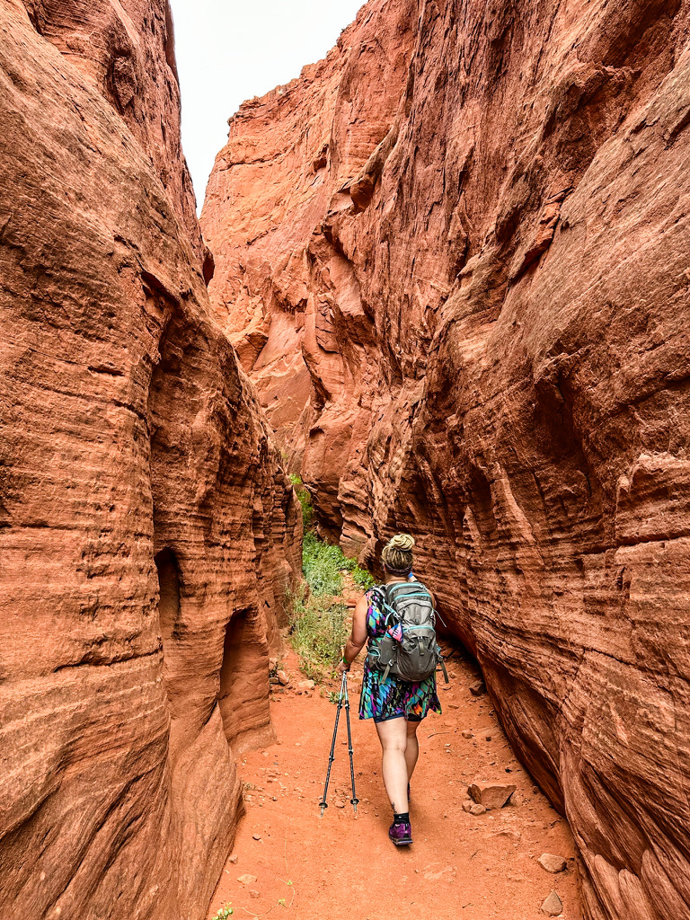
This hike was honestly breathtaking. The geography blew my mind. I’d never been in an actual slot canyon before, and the red rock formations coupled with the moody gray sky and the vivid green foliage took my breath away.


Gilman Tunnels
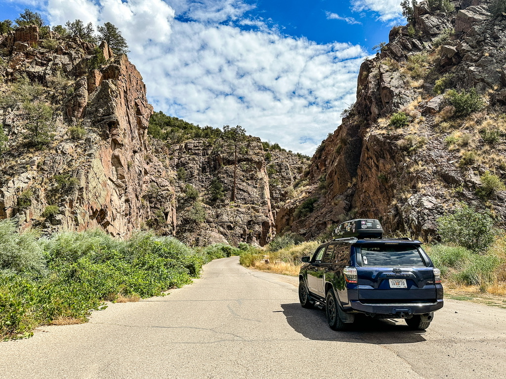
After the hike we had a picnic lunch of lettuce wraps before heading to our next stop: Gilman Tunnels. I found some information on these tunnels on AllTrails and a few other internet websites but was unsure exactly what to expect. We drove slowly down NM485 through tribal land before entering the national forest. As best as I can tell, this road is sometimes closed which is why it is listed as a “hike” in some places. However, on the day we visited the road was open and we were able to drive through the tunnels, which are alongside the Rio Guadalupe. These tunnels were constructed as part of the Santa Fe Northwestern Railroad in the early 1900’s to haul lumber, and the box canyon as well as the road have been used as locations on several major Hollywood films.

The Soda Dam
Up next was the Jemez Springs Soda Dam. This unique geological formation is estimated to be more than 7,000 years old, and is believed to have been formed from calcium carbonate and travertine deposits from the hot springs that naturally occur here. While more than 300ft across and 50ft high– spanning the width of the Jemez River– it actually used to be much larger. Part of the naturally occurring “dam” was destroyed to create the highway that now runs right past it.
We stop at the roadside attraction and one of the first things I notice is the distinct smell. It isn’t quite the same “sulfur” smell of springs back east, but it is similar. It smells slightly acrid, slightly sweet, and lends the air a crisp quality. The Jemez River plunges through the Soda Dam into a small underground cascade before continuing on its path.


Spence Hot Spring
Our final stop before continuing on to Durango was Spence Hot Springs, though Spence “Warm” Springs is a more appropriate name. A small trailhead with room for several cars right off NM SR4 marks the beginning of the short but steep trail to the springs. The trail initially switches back several times down to river level, then crosses the river on a foot bridge and continues steeply back up the other side, gaining about the same amount of elevation as was originally lost. The hike culminates at a large impacted area that I’m sure is often used for camping just above a bi-level natural spring. At a year-round temperature of around 95 degrees, it’s more warm than hot, but the absolutely breathtaking setting make this spot worth the trip.
| HIKE DETAILS | Red Rock Trail & Walatowa Slot Canyons |
|---|---|
| Trailhead coordinates: | 35.64507, -106.72576 (Park and pay at visitor center) |
| Fee: | Free! |
| Hike length: | 0.72 miles |
| Ascent: | 112ft |
| Total Hike Time: | 41min |
| Surface: | Trail with some rocks, roots, and washouts |
| Tink’s difficulty rating: | Easy-Moderate |

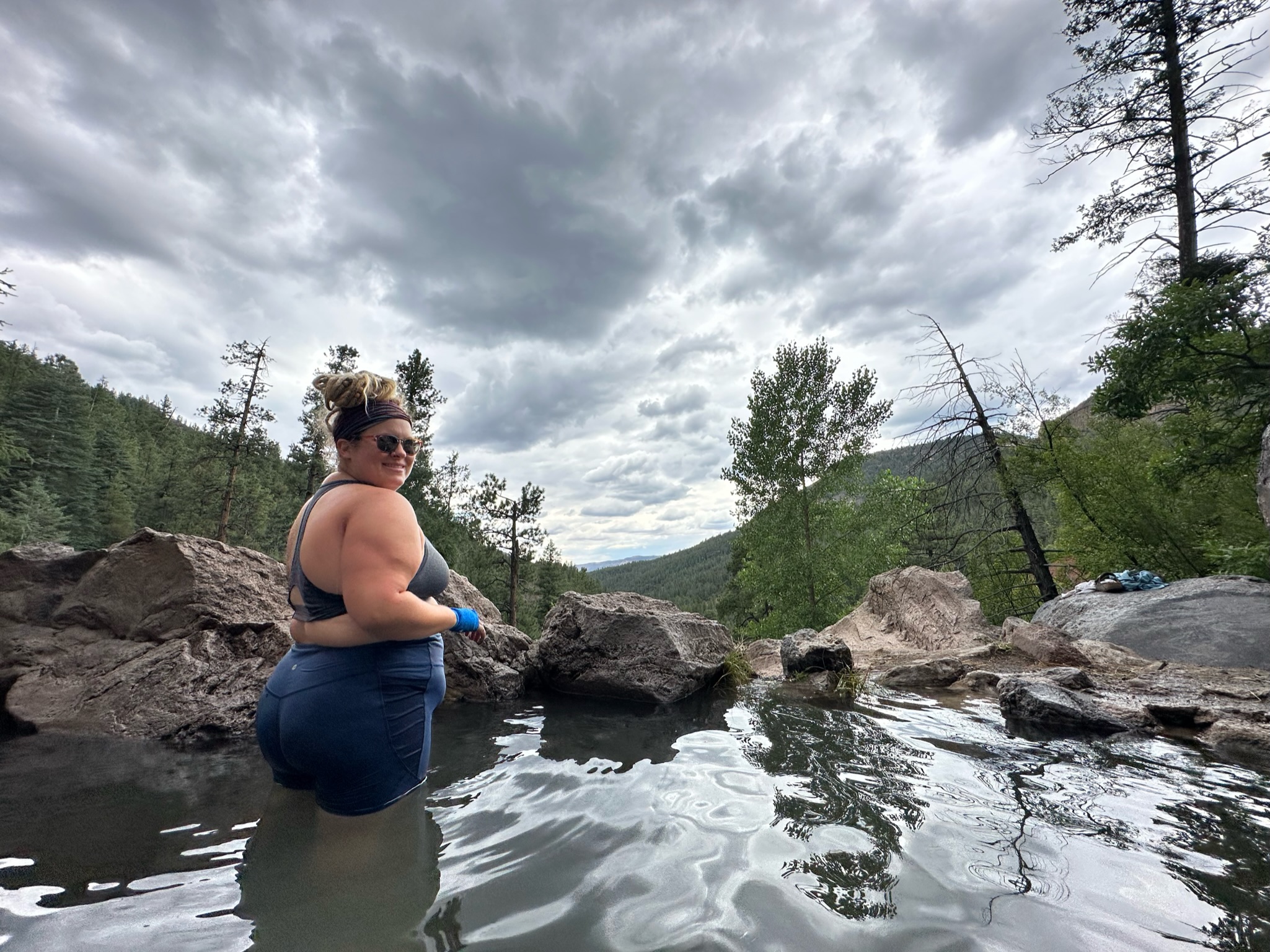
We weren’t quite sure what to expect, but were pleasantly surprised, even if we did have to share the springs with several other groups and their kids. Parents take note: this and several other springs in the area are considered “clothing optional” so bring the kiddos at your own risk. I decided to peel off my hiking dress and get into the water in my shorts and sports bra, but if I’d had any foresight at all I’d have brought a swimsuit.
Taking the long way around
With our appetite for touristing satiated, we set our sights on Durango. I’d noticed that NM 126 cut between Jemez Springs, where we were, and Cuba, NM/Hwy 550, where we needed to be. What I didn’t notice was that several miles of this road are dirt. We quickly left pavement behind and switchbacked up and over a backcountry mountain pass, encountering free-roaming cattle and spectacular views along the way.

Back on 550 after a wild ride, we had a pretty straight shot to Durango, where we met up my friend Matthew at The Nugget– a small bar between Durango and Silverton. Matthew and I met a few years ago when he was working a Forest Service job in Franklin, NC, where I live. He has since moved back to Colorado and offered us a place to crash for a few days at his cabin near Durango. He will also be joining us for a few activities in the coming days. Stay tuned!
